
SAN FRANCISCO and MOUNTAIN VIEW, Calif. — September 16, 2026 — Earth Fire Alliance (EFA) and Muon Space today released first light imagery and inaugural views of active fire from the first three operational FireSat satellites that reached orbit July 7. The images were collected approximately three weeks post launch by the advanced multispectral infrared instruments aboard all three satellites. The collection spans three continents and represents a range of fire types and sizes—from small, relatively cool hotspots to a large, intense fire.
This release marks a step change in global space-based wildfire detection and monitoring. While it’s not new to monitor wildfires from space, the multi-purpose systems currently relied upon don’t see fires with sufficient detail or frequency for many applications. The FireSat constellation, which was built for EFA by Muon Space specifically for early fire detection, detailed resolution, and rapid revisit, delivers both precision and cadence.
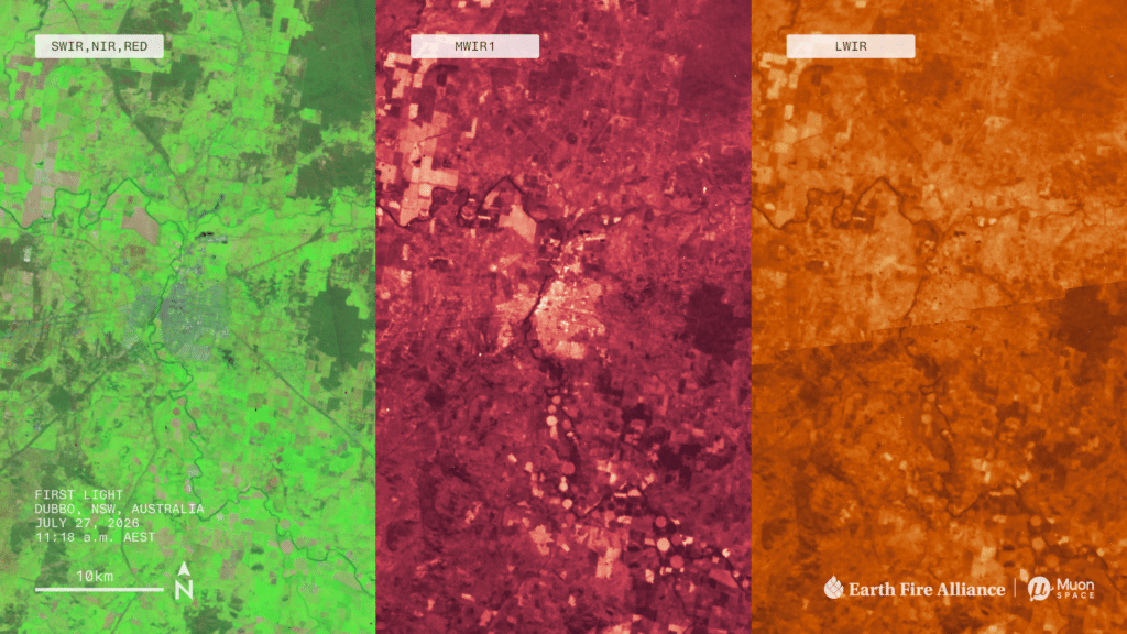
The first image the recently launched FireSats captured and sent back to Earth after reaching orbit—known as “first light”—is a view of Dubbo, New South Wales, Australia, and the surrounding area:
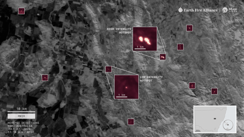
In the same pass, FireSat detected several small, cool fires scattered across surrounding farmland that are associated with managed agricultural, hazard reduction, or cultural burns:
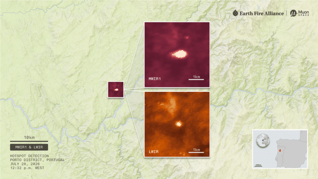
The following day, the constellation detected a single hotspot in the hills of Portugal’s Porto District. EFA partners in the country confirmed this was the end stages of a small, regional wildfire:
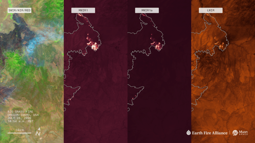
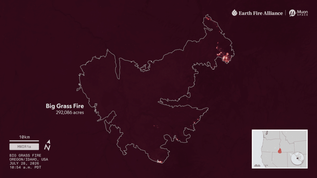
Central to the imagery package is the Big Grass Fire along the Oregon-Idaho border in the United States. At the time of data collection, the fire had already burned 290,000 acres—about the size of Los Angeles. This fire involved grass, rangeland, heavy sagebrush, and scattered timber. Grass and shrub landscapes account for most of the land that burns in the U.S. Between 1990 and 2020, grass and shrubland fires burned more than twice the area of forest fires nationwide and accounted for nearly two-thirds of homes lost to wildfire. In the following image, each of the FireSat bands answers a different question—what vegetation is available to burn, where the front is, how intense the fire is, and what is still smoldering behind it:
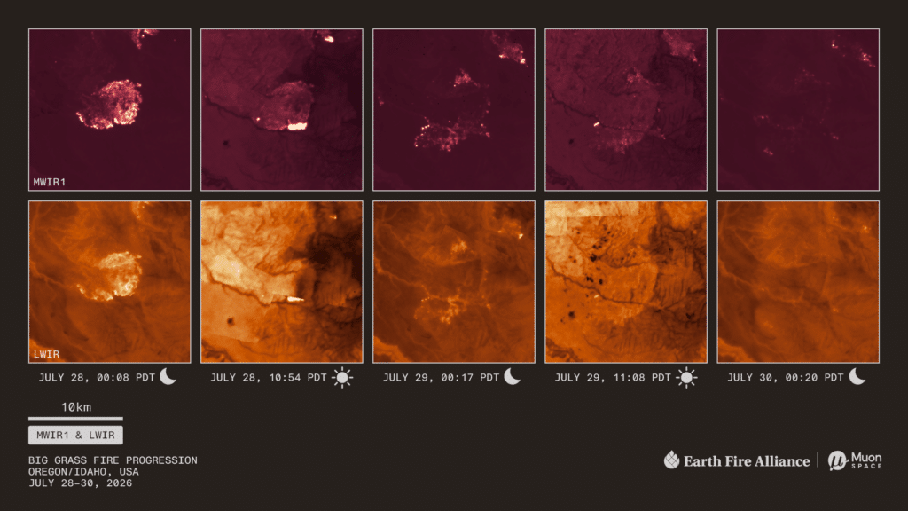
The three FireSats captured five views of an active front in the Big Grass Fire over three nights and two days, illustrating the power of a more frequent revisit rate:
“These images would not be possible without the support of philanthropists who funded this technology, dedicated engineers who built a sophisticated instrument dedicated to the fire community, and fire agencies and scientists who took the time to share their needs,” said EFA Executive Director Brian Collins. “Because of them, we can now detect fires that were otherwise undetectable from space and watch how a fire behaves over time, at a resolution detailed enough to see the front move and evolve. That’s the critical difference between knowing a fire exists and understanding what it will do next.”
EFA and Muon Space launched the FireSat Protoflight demonstration mission in March 2025, which validated the system architecture and returned valuable sample datasets to inform iterative design.
“Protoflight proved that FireSat can detect and track fires from space with the speed, precision, and sensitivity we designed it for,” said Muon Space CEO Jonny Dyer. “Now we’re taking that capability from a single satellite to an operational constellation. With these first three satellites, FireSat begins the path toward a global system that gives communities and first responders the information they need to catch wildfires early and act before they become catastrophic.”
What’s Next
The three FireSats launched in July are in commissioning, and operational FireSat data will be delivered to EFA’s Early Adopters—fire agencies and scientists across the world’s most fire-prone geographies—at least twice daily by the end of 2026. Data availability will expand throughout 2027 to support fire science and wildfire resilience activities, with global access anticipated by 2028. The FireSat constellation is expected to achieve an hourly global revisit by 2029 and a 20-minute revisit rate in the early 2030s.
EFA’s FireSat program is the product of public-private-philanthropic partnerships. The Bezos Earth Fund, Google.org, the Gordon and Betty Moore Foundation, the Patrick J. McGovern Foundation, and others funded the constellation’s development. EFA’s worldwide network of partners and Early Adopters, including Google Research and the Environmental Defense Fund, contributed to the early technological innovation that led to this milestone.
About Earth Fire Alliance
Earth Fire Alliance (EFA) is a global nonprofit coalition building the technological infrastructure the world needs to detect, monitor, and understand fire — and delivering critical data to the firefighters, scientists, and communities who need it most. EFA’s flagship program, FireSat, is the first satellite constellation designed specifically to address the wildfire challenge: generating an unprecedented dataset on fire and its effects on people and the planet. EFA partners with operational agencies, scientists, and technologists across continents to make fire data globally accessible, actionable, and available for the public good.
Earth Fire Alliance Media Contact: Kristin Q. Cody, [email protected]
About Muon Space
Muon Space is the Mission Foundry, designing, building, and operating high-performance satellite constellations for defense, civil, and commercial customers. Founded in 2021, the company has engineered every layer: spacecraft, instruments, software, and operations, all designed to work together from simulation to orbit. With advanced production facilities in Silicon Valley and multiple constellations already on orbit, Muon delivers in months, not years. For more information, visit: https://www.muonspace.com/.
Muon Space Media Contact: Michael Sias, [email protected]