
By Dr. Michael Falkowski, Chief Scientist, Earth Fire Alliance
Trusted data turn an early fire detection into action on the ground, provide a reliable foundation for fire progression models, and enable scientists to track how fire is changing worldwide over time. Building that trust starts with knowing how accurate the data are, and which applications they are best suited for. This is why Earth Fire Alliance (EFA) and our founding technical partner , o FireSat representa um avanço fundamental na forma como o mundo detecta, responde e entende os incêndios florestais. are launching a rigorous calibration and validation (also known as “cal/val”) campaign for FireSat—EFA’s advanced satellite constellation designed specifically for wildfire detection, monitoring, response, and global fire science. EFA is also helping lead the charge to establish cal/val standards for all next-generation wildfire satellites.
The first three operational FireSats launched in July 2026 are now collecting data, and the constellation will expand to more than 50 satellites by the early 2030s. Over the next several years, our cal/val campaign will compare FireSat data against independent fire measurements on the ground, in the air, and from other satellites. Results from these activities will be published throughout the campaign in collaboration with our partners across the wildfire management and science communities.
Our ultimate goal is to deliver globally trusted, scientifically validated FireSat data products to enable transformative advances in wildfire detection, tracking, management, science, and modeling.
Defining Calibration and Validation
When a FireSat satellite first launches, the images collected by its sensor don’t indicate how hot or cold objects in the image actually are. Like a photograph, the images simply show how bright or dark objects are. Calibration is the process of establishing exactly how brightness values in the image translate to actual temperatures on the ground. By comparing FireSat data with known temperature measurements of Earth objects, scientists and engineers produce “calibrated” data that measure surface temperature, including fires. This process starts in the lab before launch, and continues for the life of each satellite, because sensor performance can change as the system ages in space.
While calibration makes it possible to translate standard images into temperature measurements, validation is the process of determining how accurate those measurements are. For example, when FireSat detects a hotspot, fire managers need to know how likely that hotspot is to be an actual fire, rather than a hot object like a metal roof radiating heat, and how well the location of the hotspot detected by the satellite matches the actual location of the fire on the ground. Similarly, other FireSat derived fire attributes like size, progression, and intensity need to be verified, so data users know they can trust that data for their specific applications.
Consider, for example, a bathroom scale: calibration teaches the scale what a pound (or kilogram) is; validation confirms you can trust the readings when you step on it.
Together, calibration and validation will ensure that FireSat accurately detects fires and measures fire location, temperature, size, and intensity, so fire managers can make more informed decisions on when and how to intervene. This process also ensures the data collected by FireSat are consistent over time, allowing scientists to understand how fire dynamics are changing across the globe.
How the Campaign Works
Calibration happens in three stages:
- Pre-launch: The process of testing and characterizing instrument performance in a cleanroom or specialized laboratory before it goes into space.
- On orbit: Because instruments shift during rocket launch and age or warm up differently in the harsh environment of space, scientists must continually update and adjust pre-launch calibration equations on orbit using ground targets with known amounts of visible and infrared light reflecting or emitting upward (e.g., buoy water temperature monitoring networks, oil and gas flares, and stable ground targets like salt flats). Imaging the stars and the moon are also helpful in this process.
- Cross-calibration: Comparing FireSat with civil science-grade satellite systems such as NASA’s MODIS, NOAA’s VIIRS, or ESA’s SLSTR instruments ensures FireSat data are consistent with other long term satellite derived global fire data.
Validation occurs via a multi-tiered approach:
- Ground: Instrumented prescribed burns with direct measurements of fire characteristics such as location, size, and intensity.
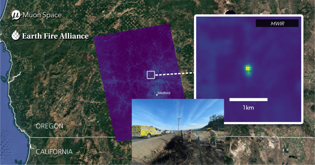
- Airborne: High-resolution thermal imaging of fires from drones and crewed aircraft, coordinated with ground measurements and overpasses of FireSat and other satellites.
- Satellite: Benchmarking FireSat data product (hotspots, perimeter, progression, fire radiative power) performance against fire data products derived from traditional science-grade satellite systems like MODIS and VIIRS.
These tests cover FireSat’s core data products and other significant factors:
- Hotspots: Probability of early-stage fire detection, false positive rates, and how quickly notifications reach end users.
- Fire Perimeter and Progression: How accurately FireSat maps a fire front, size, and progression. This can also help distinguish active flaming fire fronts from smoldering fires and hotspots and hold-over fires within the fire perimeter.
- Fire Radiative Power: How accurately FireSat measures a fire’s intensity, especially in the most extreme fires.
- Geolocation: How closely FireSat’s reported location for each fire matches its true location on the ground. For first responders, precise fire location is paramount.
- Atmospheric & Landscape Effects: The campaign will also measure how attributes like topography, tree cover, smoke, aerosols, and atmospheric water vapor affect fire measurement accuracy.
Initial Testbed Locations: Alaska and Georgia
Prescribed fires (also known as hazard reduction burns) are the backbone of our developing satellite cal/val campaign. Their planned ignition times and locations offer opportunities for collecting ground truth data that a spontaneous wildfire cannot. Our first two testbed locations will combine FireSat overpasses, scheduled prescribed fires, and the support of local scientists and fire managers.
Alaska, USA: FireSat’s orbits converge at high latitudes. Even with three operational satellites in orbit, FireSat already passes over Alaska 15 to 20 times per day, enough to capture a single prescribed fire across its full life cycle. That makes Alaska an ideal site for a near-term, high-cadence testbed, years before the full FireSat constellation is in place.
Southeastern USA: In an average year, Georgia experiences about 5,000 acres of wildfire and 1.2-1.4 million acres of prescribed fire. Frequent burns at sites such as Fort Stewart and the Oconee National Forest, engaged operational users, and nearby researchers make the region a great long-term testbed for detailed uncertainty assessments and for shaping data products around what users need.
We plan to add more testbed locations, including internationally, as the FireSat cal/val campaign progresses.
Partnering with the Global Fire Community
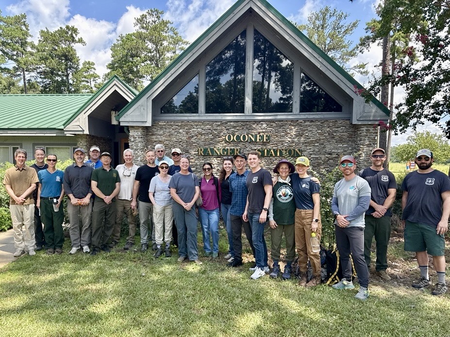
No single organization can efficiently and effectively validate a new class of fire satellites alone. In August 2026, EFA convened nearly 30 participants from federal science and land management agencies, research institutions, satellite providers, and operational fire managers at the U.S. Forest Service’s Forestry Sciences Laboratory in Athens, Georgia, for the first of several planned workshops to establish global cal/val standards for next-generation satellite systems that can detect and monitor wildfire.
Co-led with the U.S. Department of War, the U.S. Forest Service, and FireWERX, the workshop began developing a shared framework for calibration, validation, and uncertainty assessment. Though FireSat is a primary focus, this framework is intended to serve all next-generation fire satellite systems for the global public good.
The Value of Federal Civil Flight Heritage
Long-running public missions are central to this work. For example, NASA’s MODIS and NOAA’s VIIRS and GOES systems provide an anchor point for global fire science and will be key references for calibrating FireSat data.
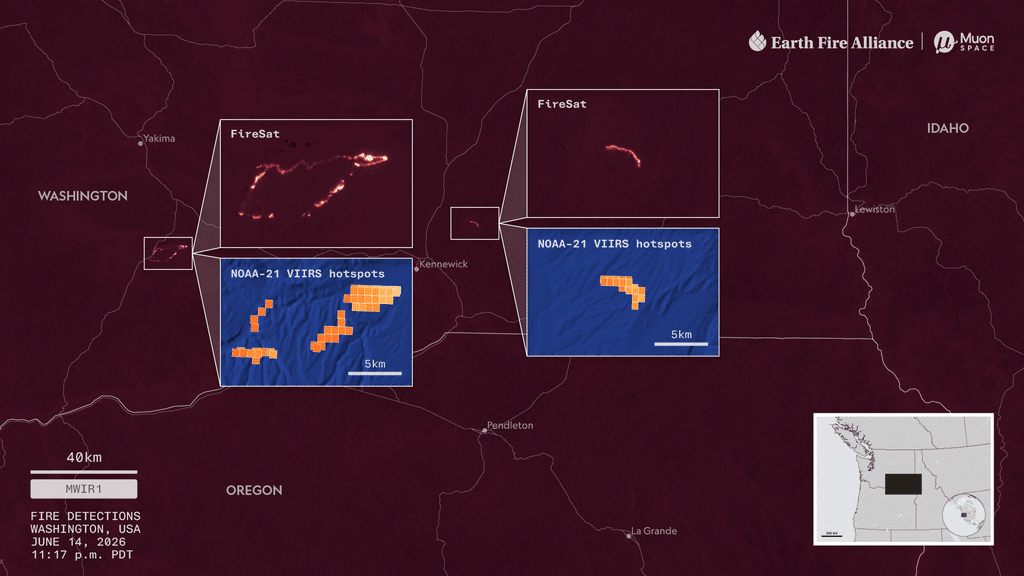
Polar orbiting satellites such as MODIS and VIIRS capture large fires a few times a day while geostationary systems such as GOES image every few minutes at coarser resolution. The FireSat program was developed to deliver both high resolution and frequent cadence simultaneously. Traditional multi-purpose systems balance fire measurements against many other applications, but FireSat is the first constellation where the wildfire management and fire science missions dictated the specific advanced system design requirements.
O que vem a seguir
The first three operational FireSats are now in commissioning and undergoing initial on-orbit calibration, with early fire validation events planned for 2027. As the constellation moves into operations, the campaign will add continuous calibration monitoring and routine validation reporting.
Collaborating with a global network of research institutions, fire management agencies, federal science agencies, and international bodies will help us accurately and consistently measure and understand fires worldwide. Later phases will integrate FireSat data into fire atmosphere and emissions models and advanced fire spread modeling. An independent scientific advisory group and periodic external review will oversee the work, and we will report validation results publicly.
Ultimately, these calibration and validation efforts will help EFA establish FireSat as the gold standard for a transformative, permanent repository of wildfire data for science, policy, and response worldwide.